The weekend was beautiful, with weather warm and for the most part, clear skies. We continued to look for new trails to hike and believe me when I say there are plenty around here. The trick, for me, is to find the ones I can do. While I will not allow my physical conditions to stop me from living life to the fullest, I do need to pay attention to them. Walking is not really a problem for me and is a matter of conditioning and strengthening the legs, steep inclines are a totally different creature. Inclines that are more gradual are not so hard on my breathing, but the ones that incline at a steep rate have me gasping for air. Of course, many of the trails that seem the best places are the more difficult ones. Good thing I appreciate irony!
 Saturday morning found us headed to Newfound Gap which is on the North Carolina, Tennessee border. We had several reasons for picking this trail. First, it is a spot where you can pick up the Appalachian Trail (AT). This trail is well known and many people cover the entire 2,200 miles of it each year, from Springer Mountain, Georgia thru to Katahdin, Maine. A great many more hike parts of it each year. A second reason is that it is one of the three trails that access Mount LeConte. I hope to make it to the top of Mount LeConte before summers end but understand it is a goal I will have to work for by getting in very good shape. The AT does not go the Mount LeConte but the Boulevard trail veers off from it and does. More will be revealed about this as the summer passes. The third reason is the sheer beauty of the spot.
The parking lot at Newfound Gap is large and it was full. After finding a parking space we located where the AT continues and we started the hike, along with about 70 other people. The array of people was amazing. There were all ages, all degrees of fitness and all with different intentions as they passed this portal. By looking at the gear people had, it was clear some were there for a casual walk until they were tired and would turn around, some were planning on a day hike with probably a point in mind and some were hiking either the trail or at least a portion of it. We were day hikers with a point to reach, in mind. We spoke to one young lady who had started in Georgia and planned to do the entire trail. She has hiked many trails around the world. Another man I spoke with was a day hiker. He started to hike two years ago to “get in shape” while weighing 300 pounds. I did not ask but he looked to me to be no more that 220 so it seems to be working for him. Whatever the reason or the intention I love seeing so many people hiking and enjoying nature.
The beginning of the trail was steep. It required climbing stairs, climbing rocks, using tree roots as steps and, oh yeah, mud, slippery, gooey mud. The going was slow because of the number of people and the fact that I had to stop to catch my breath so often. I also stop to let the faster moving folks breeze on by. I remember those days of young legs and explosive energy, but I am ok with where I am. As a matter-of-fact, I am very grateful. From our first step on this trail I loved it. Ever step was exactly how I imagined the AT would be. It was rugged and wild even in this part so well traveled. In places only one person at a time could pass through a spot.
The crowd thinned and the peace and quiet of the trail settled in on us. The wind through the trees provided a soundtrack in the background for the day, as nature played new compositions on wooden-wind instruments. The accompanying light show delicately modulated from deep shadows in the heavily wooded areas to a showy array of colors as the sun played across the deep, rich earth colors coming alive with the spring.
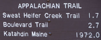
At 1.7 miles we reached the turnoff for the Sweat Heifer Creek Trail. It is interesting because we begin to see how many of the trails are connected. If we followed this trail for 3.7 miles it will take us to the Kephart Prong Trail which we have hiked a few times. It might be an option one day as it is basically downhill from the AT junction to Kephart, and Kephart is downhill to the road. But today we go forward to where we will leave the AT for a while as we headed to the cliff at the end of Jump Off Trail.
 Along the way are markers indicating the AT. Spots of paint on the trees show the way. I notice there have been a number of people who felt the need to carve their initials on the trees as well. I have never understood the desire to do that, nor the satisfaction that the person must feel after performing the feat. It reminds me of a poem I wrote during a visit to Spain years ago. I guess it is just another one of those things about life that I will never come to really grasp.
Our next marker is a mile away at the fork where the AT veers to the right and the Boulevard Trail to the left. We made progress with me stopping as needed. There is a gain of about 1200 feet in the 3.5 mile uphill climb. When we reach the Boulevard Trail it is a short walk to the Jump Off Trail. This trail is pretty steep and difficult in couple of places. It comes to a dead end with a spectacular view of the mountain range. We have our lunch here and enjoy the view. A Dark-eyed Junco decides to join us for lunch, patiently waiting for any crumbs that hit the ground.
When we were finished, we made the trip back down the trail. Going up is  hard on me because of the breathing, but going down is almost harder because of the balance needed to not fall. I did slip and fall at one of the more difficult parts of the Jump Off trail, but other than a couple of small scraps I was ok.
Maybe a course on first aide would be a good thing to look into…